 Add Row
  Add
Add 

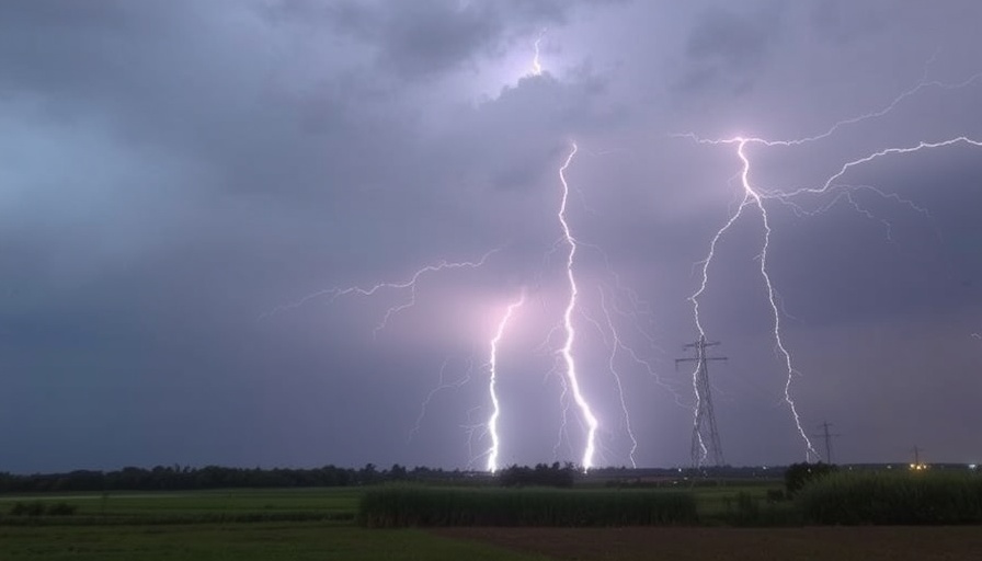
Weather Alert: Thunderstorms Set to Impact Southern California
Residents of Bakersfield and surrounding areas in Southern California should brace themselves as thunderstorms are expected to roll in on Tuesday morning. According to forecasts, these storms may bring with them heavy rainfall, strong winds, and lightning, raising the risk for flash flooding—especially near burn scars from previous wildfires.
What to Expect: Heat and Humidity
Tuesday promises to be another hot and humid day, with temperatures soaring into the 90s and even reaching triple digits in some areas. Heat advisories have been issued for inland areas including Orange County, as well as the San Bernardino and Riverside valleys. This combination of heat and incoming thunderstorms creates a volatile weather situation that warrants caution and preparedness.
Flooding Risks: A Serious Concern for Local Areas
With thunderstorms looming, a flood advisory has already been activated for San Bernardino County until 9:44 AM, impacting regions such as Big Bear. Experts warn residents to remain alert for potential flooding and debris flows, particularly in the San Gabriel Mountains and the Antelope Valley. It’s essential for community members to stay weather-aware and to take precautionary measures if necessary.
Preparedness: Staying Safe During Thunderstorms
During severe weather events, safety is paramount. Residents are advised to seek shelter upon hearing thunder, and to stay indoors until conditions improve. Keeping a kit ready with essentials like water, canned food, and a flashlight is a good practice, not just for this storm season, but for any extreme weather that might befall the area. Don’t forget to advise friends and family members about the potential storm; sharing knowledge can often save lives.
A Community United: Supporting Each Other Through Adverse Weather
During events like these, the spirit of community shines bright. Neighbors helping neighbors can make a difference; whether it’s checking in on the elderly, sharing resources, or simply offering a kind word. The more we come together, the better we can weather the storm—literally!
Future Trends: What This Means for Upcoming Weather Patterns
After this bout of storms, a slight cooling trend is predicted starting Thursday, with temperatures dropping 5 to 7 degrees over the weekend. It is essential to monitor these changes as they can provide relief from the heat, but coupled with storms, they may bring other challenges. Understanding these patterns will allow residents to better brace for future weather events.
Conclusion: Stay Informed and Prepared
In conclusion, as we gear up for the incoming thunderstorms, it’s crucial to be informed and to take actionable steps to ensure safety. Keep an eye on local news reports for updates and alerts as the situation unfolds. Remember, together we are stronger, and being prepared is key. For more updates on local weather, stay connected with your community and the local news.
Embrace the spirit of community by looking out for one another during these unpredictable weather patterns. Stay safe and keep each other informed!


Write A Comment